The coast
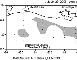
wide extent of the Louisiana “dead zone” mapped
this week (July 24-29) is 11,840 square kilometers (or 4,564
square miles), slightly smaller than the size of Connecticut,
reported Dr. Nancy Rabalais, Chief Scientist for Northern
Gulf of Mexico Hypoxia Studies. The low oxygen waters extended
from near the Mississippi River to the Louisiana/Texas border.
The long-term average since mapping began in 1985 is 12,700
km2 (or 4,800 square miles).
The scientific
word for the commonly named Dead Zone is ‘hypoxia,’
or low oxygen, which results in the failure to capture fish,
shrimp and crabs in bottom-dragging trawls when the oxygen
falls below the critical level of 2 ppm. Higher in the water
column and on both inshore and offshore sides of the hypoxic
area, there is sufficient oxygen to support sizeable numbers
of fish. The net result, however, is a sizeable stretch of
the Louisiana coast unsuitable for supporting fish and shrimp.
The seasonal
formation and persistence of hypoxia are influenced by the
discharges and nutrient loads of the Mississippi and Atchafalaya
rivers. The fresher water forms a layer above the saltier
Gulf waters. Nitrogen and phosphorus in the river water stimulate
the growth of microscopic plants, the phytoplankton. These
algae are either transferred into the food web or end up as
organic debris on the sea floor. Their decomposition by bacteria
depletes oxygen in the lower waters until they no longer sustain
the life of most marine animals.
Water
depths affected were as shallow as 20 feet and as deep as
85 feet. The hypoxic zone was smaller between the Mississippi
River and the Atchafalaya on the central Louisiana coast than
between the Atchafalaya River delta and Calcasieu estuary
to the west.
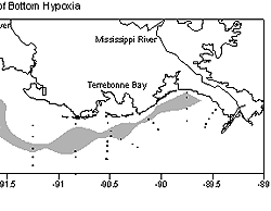
Steve
DiMarco and colleagues at Texas A&M University and also
the National Marine Fisheries Service groundfish survey both
conducted cruises in the area Louisiana hypoxia in early July
before the landfall of Hurricane Dennis on the Florida coast.
Their sampling grids were limited to the southwestern Louisiana
shelf, but they also found hypoxia between the Atchafalaya
River and the Calcasieu estuary.
The size
just mapped was smaller than predicted using a model developed
by Dr. Eugene Turner of Louisiana State University, an investigator
of the research team, that relates the size with the May nitrate
load along with a term that adds the influence of the previous
year’s nitrate load. Turner predicted a size of 6,200
square miles, which was larger than the measured size of 4,800
square miles. The smaller than predicted size was expected
because of a tropical storm and hurricane that affected the
area between the Mississippi and the Atchafalaya rivers earlier
in July. While the two-layered system that supports the formation
of hypoxia was redeveloping at the time of the mapping cruise,
the oxygen level beneath that layer had not fallen below 2
ppm again. “I would predict that a somewhat larger area
of hypoxia would have been mapped if the cruise had been conducted
one week later than planned and therefore closer to the size
modeled by Turner,” said Rabalais. Confirmation of this
prediction may come from the oxygen measurements taken by
the NMFS groundfish survey that finished their work on the
southeast Louisiana coast on July 27 – August 31.
Scientists
from the National Atmospheric and Oceanic Administration predicted
this summer’s dead zone to be less than 1,400 square
miles based on nutrient loads from the Mississippi and Atchafalaya
rivers in May and June. While high in late winter and early
spring, the nutrient loads were lower than average this year,
probably due to below average precipitation across much of
the Mississippi River Basin. The multiple models will help
evaluate the influence of the nitrogen load and variations
in the physical structure of the offshore coastal waters to
improve assessments of hypoxia.
Additional
research conducted on the cruise was focused on the effects
of varying levels of hypoxia in controlling mercury methylation
in bottom sediments. These studies were conducted by Dr. David
Senn, Harvard School of Public Health, and funded by NOAA’s
initiative on Oceans and Human Health.
The scientific
party that mapped this year’s zone was from LUMCON,
LSU, Harvard School of Public Health, and Nicholls State University,
and was funded by NOAA’s Center for Sponsored Coastal
Ocean Research, part of the Ocean Service’s National
Centers for Coastal Ocean Science. The mapping was conducted
from July 24-29 from aboard the research vessel, Pelican.
For further
information contact Dr. Nancy Rabalais, LUMCON, 985-851-2801,
nrabalais@lumcon.edu.
Back
to Main