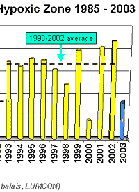
Two
tropical storms in as many weeks have mixed up the coastal
waters of the northern Gulf of Mexico and disrupted the usual
widespread extent of summertime waters severely depleted in
oxygen, reports Dr. Nancy Rabalais of LUMCON who just completed
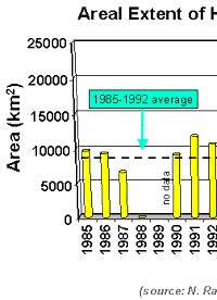
this summer’s mapping. The result was a half again smaller
“dead zone” this summer than the average size
for the last 10 years. The size just mapped on a six-day cruise
was 8,560 square kilometers (=3,300 square miles).
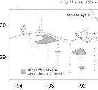
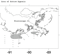
Larger
patches of water with low oxygen were located near the Mississippi
River delta off Terrebonne Bay, off Atchafalaya Bay, and along
the southwestern Louisiana coast near Calcasieu estuary. Smaller
patches were located farther offshore. The Texas coast was
spared from low oxygen waters, but also received the brunt
of Hurricane Claudette on July 7-8. Tropical Storm Bill crossed
the Louisiana coast near Morgan City on June 30. Both storms
created 10 to 15 foot seas along the Louisiana coast. The
waves mixed well-oxygenated waters from the surface down through
the water column. Eventually hypoxia will reform.
The scientific
word for the commonly named Dead Zone is “hypoxia,”
or low oxygen. Dead Zone refers to the failure to capture
fish, shrimp, and crabs in bottom-dragging trawls when the
oxygen concentration falls below a critical level in bottom
waters. Higher in the water column, however, there is sufficient
oxygen to support sizeable numbers of fish and swimming crabs.
The seasonal
formation and persistence of hypoxia are influenced by the
discharges of the Mississippi and Atchafalaya rivers. The
fresh water forms a fresher layer above the saltier Gulf waters,
and the resulting two-layer system inhibits the oxygen in
the surface waters from penetrating to depth. Nutrients stimulate
the growth of microscopic plants, the phytoplankton. These
single celled plants either end up in the food web, which
off Louisiana supports valuable commercial fisheries, or end
up as organic debris on the sea floor. The decomposition of
this organic matter by bacteria uses up the oxygen to the
point that it becomes depleted and lower than what is necessary
to sustain the life of most marine animals.
High river
discharge in spring 2003 and another peak of fresh water to
the Gulf in June, along with the nutrients carried in the
flow, started the annual progression of hypoxia. Hypoxia was
well established and widespread along a line of stations off
Terrebonne Bay sampled in mid-June. At that time, eight of
nine stations out to 100-ft water depth were severely depleted
in oxygen, said Dr. Nancy Rabalais, who studies hypoxia in
the region. She’s chief scientist on the project based
at LUMCON.
Several
mathematical models based on the amount of river discharge
and nutrients loaded into the Gulf of Mexico in spring and
early summer 2003 predicted that the size of this year’s
low oxygen area would be in the range of 15,000 to 17,000
square kilometers (=6,000 to 7,000 square miles). The models,
however, do not take into account the mixing that resulted
from the two tropical storms that passed through the hypoxic
zone two to three weeks before the mapping cruise, she added
“It
was obvious that the water column was more mixed than in most
summers,” said Rabalais. Even with a very strong signature
of Mississippi and Atchafalaya river water far out into the
study area, there was not the usual strong difference in temperature
and salinity from the surface to the bottom. That physical
structure is necessary for the formation of hypoxia along
with the nutrient-enhancement of the phytoplankton. “If
we were to collect these data two weeks from now, I would
predict a much larger size,” said Rabalais.
The scientific
party from the Louisiana Universities Marine Consortium (LUMCON)
and Louisiana State University is funded by the National Oceanic
and Atmospheric Administration, Coastal Ocean Program. For
further information contact Nancy Rabalais, LUMCON, 985-851-2836.